
Professional CAD Mapping & Engineering Drawing Services
CAD Mapping & Engineering Drawings involve the creation of accurate digital drawings and technical plans using advanced Computer-Aided Design (CAD) software. These drawings are essential for construction, infrastructure, surveying, and engineering projects to ensure precision and clarity in design and execution.
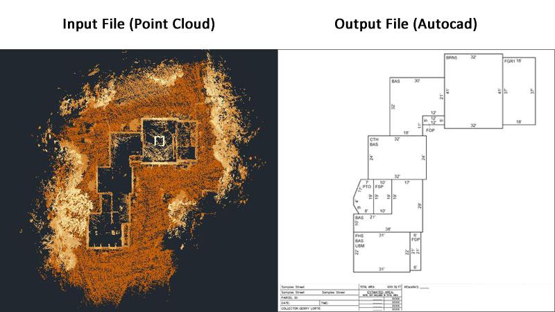
At HydroMarine Geophysics, we provide high-quality CAD drafting services and engineering drawing solutions tailored to project requirements. Our team converts survey data, point cloud data, and GIS data into precise 2D and 3D CAD drawings using industry-standard tools and workflows.
Our CAD Mapping & Engineering Capabilities
We specialize in CAD drafting, CAD conversion, point cloud to CAD, as-built drawings, shop drawings, and detailed engineering layouts. Our services support architects, engineers, and surveyors by delivering accurate plans, sections, elevations, and design drawings for efficient project execution.

Start Your CAD Mapping Project Today
Accurate CAD Drafting & Engineering Design Solutions
We provide reliable CAD mapping and engineering drawing services designed to meet your project requirements. From raw survey data to final CAD deliverables, our team ensures precision, consistency, and fast turnaround.
Whether you need CAD conversion, as-built drawings, or detailed engineering plans, HydroMarine Geophysics delivers professional solutions that support efficient design, construction, and project management.
Contact Us
HydroMarine Geophysics
We provide professional geophysical data processing and interpretation services worldwide. Contact us today to discuss your project requirements.
Address:
1 Albert Embankment,
LONDON, SE1 7XQ, UK
Phone:
+44 02045478801 / 07440309646
Email:
info@hydromarinegeophysics.com
contact@hydromarine.com
Our Project Outputs

2D CAD Drawings
Plans, Sections & Elevations
3D CAD Models
Detailed Engineering Models
Point Cloud to CAD
Accurate Data Conversion
As-Built Drawings
Precise Project Documentation